The coquina cliffs that gave Rockledge its name
Rockledge sits on the largest exposed coquina outcrop on the Indian River. The cliffs are Pleistocene Anastasia Formation, the same shell-rock that built the Castillo de San Marcos in St. Augustine. Here's why they're there and why the city was named for them.
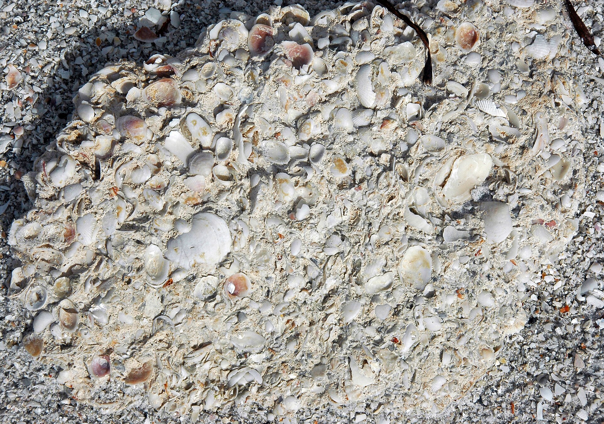
Rockledge is named for the coquina rock ledge that runs along its riverfront. The cliffs are part of the Anastasia Formation, a Pleistocene-age limestone made almost entirely of coquina clam shells (Donax variabilis) cemented together by calcium carbonate from rainwater leaching through dune sand. The Rockledge outcrop is the most prominent coquina exposure on the Indian River Lagoon and the largest natural ledge on the Florida east coast south of St. Augustine. The cliffs are typically ten to fifteen feet above the river, vertical-faced in places, and run for roughly two miles along what’s now Rockledge Drive.
The geology, in one paragraph
The Anastasia Formation deposited during the late Pleistocene, between roughly 130,000 and 120,000 years ago, when sea level was higher than today and the Florida peninsula was significantly narrower. Coquina shells accumulated in shallow nearshore environments, then got cemented as freshwater carbonate dissolved and re-precipitated within the shell mass. When sea level fell, the cemented beds were exposed. They run intermittently from St. Augustine south to Palm Beach, but the Rockledge exposure is unique because the river cut a steep face into the formation rather than the formation gradually dipping below the water.
Why coquina, and why here
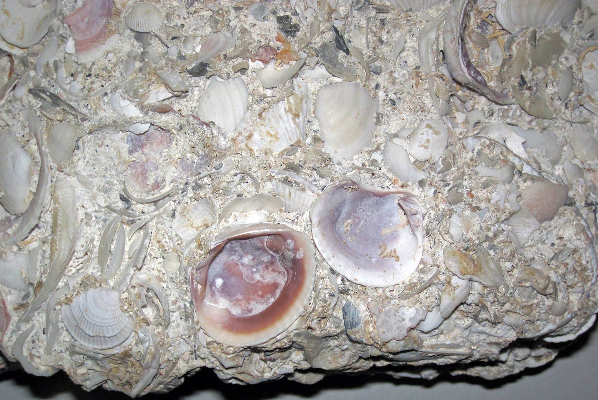
Coquina is shell. Specifically, it’s the broken and intact valves of small marine mollusks, coquina clams, donax shells, miscellaneous bivalves, that accumulated in surf-zone deposits during high sea-level stands of the Pleistocene. The Anastasia Formation is the named geological unit that contains these deposits along Florida’s Atlantic coast. The unit was first formally defined by Florida Geological Survey geologists in the early 20th century and has been mapped repeatedly since.
The Rockledge outcrop sits at the inland edge of the formation, where the coquina was deposited closer to shore and got more cement from rainwater. Further south, the formation thins. Further north (around St. Augustine), it’s even better cemented and was quarried for centuries as a building stone. The Castillo de San Marcos, completed by the Spanish in 1695, is built almost entirely of Anastasia Formation coquina from the nearby Anastasia Island quarries. Same rock, same process, two hundred miles north.
At Rockledge, the cliffs face east toward the lagoon. They formed when the Indian River cut down into the coquina during a lower sea-level stand, probably during the most recent glacial period (the Wisconsin glaciation, ending around 11,500 years ago). When sea level rose again, the river occupied the cut face, and the coquina cliff has been the eastern shoreline of dry ground at Rockledge ever since.
The naming
The first European reference to “the rock ledge” appears in the journals of 19th-century Indian River navigators. The settlement that grew up here was called Rockledge by at least 1872, when the post office opened under that name. The name describes the geographic feature. It’s not a poetic invention or a settler family name. It’s literal.
Compared to its neighbors, this is unusual. Cocoa was named (depending on which account you believe) for the cocoa palm, for a brand of cocoa powder shipped through the local store, or for a misnomer that stuck. Melbourne was named for the Australian city by a homesteader who’d lived there. Eau Gallie was named in mock-French for a creek that wasn’t called anything in particular. Titusville was named for a man, Henry T. Titus. Rockledge alone took its name from the rock under its feet.
The cliffs today
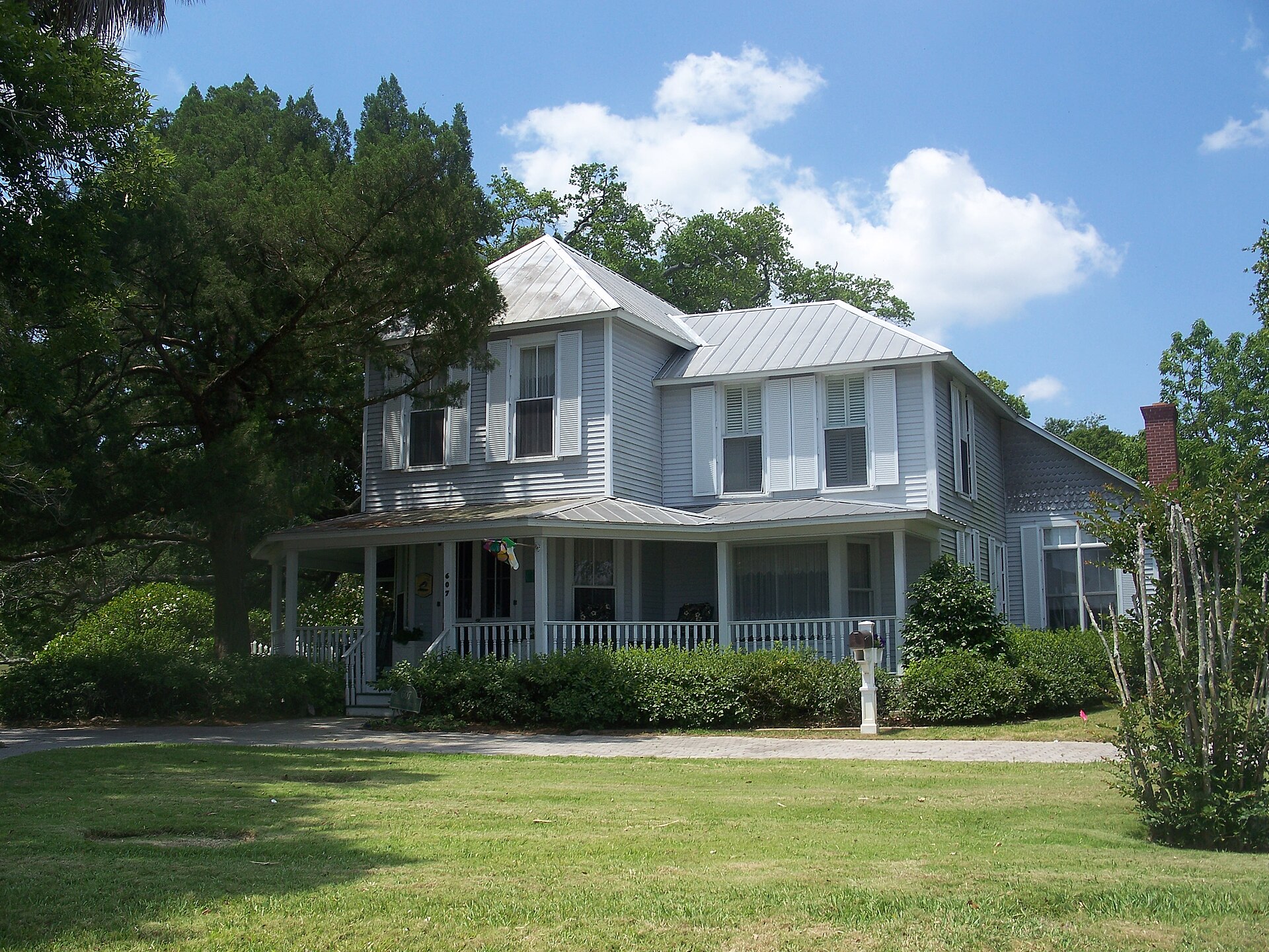
The most visible exposures are along Rockledge Drive, particularly between Orange Avenue and Pineapple Avenue. Several of the old Gilded Age residences are perched directly on the coquina face, with stairs cut down to small private docks at river level. The Rockledge Drive Residential Historic District, listed on the National Register of Historic Places in 1990, preserves both the houses and the cliff edge they sit on.
The rock is fragile in some sections, more competent in others. Where the coquina is well-cemented (the lower beds, particularly), it forms vertical cliffs that hold up to wave action and storm surge. Where it’s weakly cemented, it crumbles into the river and is eroded back. Several Rockledge property owners have built coquina retaining walls or rip-rapped the cliff face to prevent further loss.
Hurricane Frances and Hurricane Jeanne in September 2004 hit Rockledge with two storm surges three weeks apart. The combined wave action accelerated erosion along the unprotected cliff sections. City and homeowner records from 2005 and 2006 document several feet of cliff retreat in some sections. The well-cemented sections held.
Where to see the rock
The best public view is from Rockledge Park, at the southern end of the historic district, where a small walkway puts you at river level looking up at the cliff face. The rock is visibly composed of shells, with darker iron-stained streaks and occasional larger fossil shells (clam, conch fragments, the occasional vertebrate fragment). At low tide and clear water, you can see how the cliff continues below the river surface for another several feet before bottoming out.
The other public exposure is at the Rockledge Drive overlook near the H. S. Williams House. The cliff face there is partially obscured by vegetation but the rock is reachable.
How the cliffs differ from St. Augustine’s
The St. Augustine coquina is older (lower in the formation, more time for cementation), better-cemented, and was quarried in massive blocks for use as building stone. The Rockledge cliffs are younger, less competent, and have never been quarried for construction. The Castillo de San Marcos used coquina because it was the best local rock and because cannonballs embedded in coquina rather than shattering it, a property the Spanish noticed quickly. Nothing equivalent ever happened at Rockledge. The rock here was a feature of the landscape and a name for the town, never a quarry.
Why this matters
The geology is the reason Rockledge exists where it does. The high, dry, well-drained ground above the cliff is why the Hotel Indian River was built here, why the wealthy Gilded Age winter visitors chose it, why the original homesteaders planted citrus on the bluff rather than in the river-edge muck. Without the coquina ledge, Rockledge is just another stretch of low-elevation lagoon shore, and the city that incorporated in 1887 probably grows up somewhere else.
Further Reading
- Florida: A Short History by Michael Gannon
- Florida’s Fabulous Natural Places by Tim Ohr
- The Gulf: The Making of an American Sea by Jack E. Davis
Sources
- Florida Geological Survey, Special Publication 51: The Anastasia Formation in Florida, floridadep.gov/fgs
- T.M. Scott et al., Geologic Map of the State of Florida (USGS, 1980), pubs.usgs.gov/imap/i-1255/
- Thomas M. Scott et al., Geology of Florida (Florida Geological Survey Bulletin 65, 2001)
- National Register of Historic Places nomination form, “Rockledge Drive Residential Historic District” (NRHP #90000683), 1990
- Detailed coquina petrology in James L. Cooke and Reading Petrick, “The Anastasia Formation” (Florida Geological Survey field guide series, multiple editions 1970-2010)
As an Amazon Associate we earn from qualifying purchases.